
풍수 · pungsu
Pungsu: how sites were chosen
Mountain behind, water in front: what Joseon Koreans believed about land, how it shaped Hahoe and Yangdong, and the practical sense inside it.
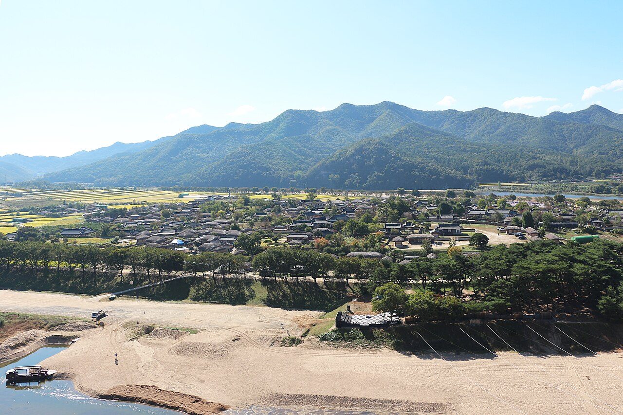
Before a Korean house was built, someone looked hard at the land. Where did the hills rise, which way did the water run, where did the wind come from, which slope caught the winter sun? The body of ideas that guided that looking is pungsu (풍수), the Korean form of what is better known in the West by its Chinese name, feng shui. The word means ‘wind and water’.
This page explains pungsu as history: what people believed, how the state and families used it, and how it shaped the places you can visit. It does not claim that a site’s energy affects anyone’s fortune. There is no evidence that it does, and many Joseon scholars said as much at the time. What is beyond doubt is that the belief was real and widespread, and that it left its mark on almost every old village, house and grave in the country.
What pungsu claimed
Oh Sang-hak, writing in the Academy of Korean Studies’ Review of Korean Studies, describes geomancy as a traditional technique for avoiding calamity and seeking good fortune by reading and orienting to jigi (지기), a vital energy believed to flow through the ground. A site where that energy gathered was a myeongdang (명당), an auspicious place, and the aim was to put a house, a village, a palace or a grave there.
Oh also stresses its practical roots. In a farming society, he notes, shelter from wind and a secure water supply were matters of survival, and the name itself reflects them: Korean writers often explain the word through the formula jangpung deuksu (장풍득수), ‘store the wind, obtain water’. Later the ideas were systematised with the theory of yin and yang and the five elements, and with the cosmology of the Book of Changes, which gave the practice its elaborate rules of direction and timing.
Mountain behind, water in front
The best-known principle is baesan imsu (배산임수): a site with a mountain at its back and water in front. A main mountain behind gives shelter; lower ridges curling round on either side enclose the site; a stream or river crosses in front. Practitioners named the surrounding landforms after four guardian creatures, which Joseon writers list as the tortoise, the phoenix, the blue dragon and the white tiger, and judged a site by how well they ‘embraced’ it.
Joseon geomancers also weighed direction. Oh records that some scholars accepted the reading of landforms while rejecting the calculation of auspicious compass directions by the eight trigrams and the sixty-year cycle, which they considered a later and less trustworthy layer.
Pungsu and the state
Geomancy reached Korea from China and became influential in the Goryeo period. Oh credits the monk Doseon with spreading it, and notes that Goryeo’s founder Wang Geon used it to lend legitimacy to his new dynasty. The founders of Joseon used it when they moved the capital from Gaeseong to Hanyang, today’s Seoul. An unofficial history records an argument over the main palace: the monk Muhak wanted it oriented to Mt Inwang, while the statesman Jeong Do-jeon insisted it face south with Mt Baegak behind it, because a king should govern facing south. Jeong won, and Gyeongbokgung was built with Baegak at its back.
Geomancy then became an institution. The Gyeongguk daejeon, the dynasty’s legal code, provided for a professor and an instructor of geomancy in the royal Office for the Observation of Natural Phenomena. Siting royal tombs was state business. When officials under King Sejong mocked the idea that fortune depended on graves or the direction of houses, the king answered that his predecessors had used geomancy for the capital and the tombs, and that its theories could be neither wholly believed nor wholly ignored.
Pungsu in the family
Among ordinary families the most intense concern was graves, since a well-sited tomb was believed to benefit the descendants. By late Joseon this produced endless lawsuits over burial sites, secret burials on other people’s land and seizures of graveyards, and Confucian scholars blamed geomancy for the disorder. Critics such as Jeong Sang-gi and Jeong Yak-yong attacked its claims about fortune, and Jeong Yak-yong complained that coastal towns were sited by geomantic theory rather than for defence.
House siting, by contrast, was widely accepted by scholars, Oh argues, because it was less mysterious. The household manual Sallim gyeongje by Hong Man-seon (1643-1715) opens with a section on choosing a dwelling site, and Yi Jung-hwan’s 18th-century Taengniji, a guide to choosing where to live, ranks the direction in which watercourses leave a site, the shape of the mountains and the colour of the soil among its first principles.
Hahoe and Yangdong
Hahoe is the classic case. The Nakdong River loops almost all the way round the village, and the site is traditionally described as yeonhwa busu (연화부수), ‘a lotus flower floating on water’. The cliff across the river from which visitors look down on the village is Buyongdae, a name taken from the lotus. Yet Hahoe does not fit the textbook. A 2023 Pressian report on the village notes that it has no mountain at its back to the north, and that its main hill lies to the east; to make up for that, villagers planted a forest on the north-west side, today’s Mansongjeong pine wood beside the river.
Yangdong is the opposite case: houses spread along ridges at the foot of a mountain, above a stream. Lee Eung-hee’s 1999 study of the two villages contrasts them through the lens of water: Hahoe’s houses sit on the inside of the river’s bend on flat land, where water conditions dominated the reading of the site, while Yangdong’s lie on the outside of its stream at the foot of a hill, where the surrounding mountains and shelter from wind counted for more.
The practical sense inside it
Strip away the language of energy and luck, and much of what pungsu recommended for a house is sound advice for a farming household in Korea’s climate. A slope facing south catches the low winter sun; a hill behind breaks the cold north-west winter wind; water in front means water to drink and irrigate; a site above the valley floor drains after summer rain. Oh describes geomancy as combining a rational side built on long experience of the land with a mysterious side that cannot be shown to work, and notes that Joseon scholars themselves drew that line. When you stand in a village and notice how it sits in the land, you are seeing the practical side made visible, whatever the people who chose the site believed about it.
What to look for
- Which way the village or house faces, and what rises behind it
- Where the water runs: in front, or wrapping round the site
- Planted groves at the edge of a village, often explained as ‘filling in’ a weak side
- From Buyongdae, the shape of Hahoe in its river bend
- In Yangdong, how the head houses sit on spurs with hills behind them
Sources
- The Recognition of Geomancy by Intellectuals during the Joseon Period (Oh Sang-hak), The Review of Korean Studies 13(1), 2010, Academy of Korean Studies, via AccessOn (read 15 November 2026)
- A Study on the Interpretation of Spatial Composition and Location of Traditional Village from the Water of Feng-Shui Theory (Lee Eung-hee, 1999), Journal of the Korean Housing Association, via KoreaScience (read 15 November 2026)
- 조선 정신문화의 산실에서, 그 크기와 깊이를 재다, Pressian (read 15 November 2026)
- [K-World Heritage] Historic Villages of Korea: Hahoe and Yangdong, Permanent Delegation of the Republic of Korea to UNESCO (read 15 November 2026)
- Yangdong Village travel feature, Money Today (read 15 November 2026)